

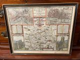
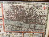
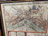
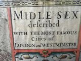
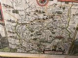
1627 john speed map of Middlesex including London and Westminster
Price
£900
| $1,228 USD | €1,043 EUR
Item Ref
Description
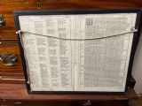
1627 John speed map showing the county of Middlesex with detailed maps of the city of london and Westminster, the map is hand coloured and in wonderful condition, the frame is double glazed to show the front and original back This map with views of London and the English county of Middlesex by John Speed was published in the 1627 edition of Speeds famous atlas The Theatre of the Empire of Great Britaine.Measures
Height 410 cms
Width 520 cms
Depth in frame 3 cms
Condition
Good
Condition: (A) Very Good Condition
Description:
This original hand coloured antique map & views of London and the English county of Middlesex by John Speed was published in the 1627 edition of Speeds famous atlas The Theatre of the Empire of Great Britaine.
Delivery can easily be arranged for this item smaller items are generally sent free of charge to the uk, larger items can be sent via a courier, I keep this service as cheap as possible, the larger items are picked up and delivered to you within 7-10 days should you require a quicker delivery expect to pay at least double the normal cost.
If you are unhappy with any item I offer a full money back guarantee once the item is safely back in my possession and undamaged as a result of misuse. Please feel free to ring me with any queries you may have, I'm always happy to discuss anything to do with antiques !!
Opening hours Thursday to Saturday 10am - 6pm.
Or by appointment.
Dimensions
Height = 410 cm (162")Width = 520 cm (205")
Depth = 3 cm (1")
We accept online payments for this item:
BUY NOW with CREDIT CARD or PAYPAL
Email about this item:

SEND EMAIL